
AZ-1 Original: Connecting for Care
One man's journey with Parkinson's has been transformed, thanks to his community, high speed internet and Zoom.
One man's journey with Parkinson's has been transformed, thanks to his community, high speed internet and Zoom.
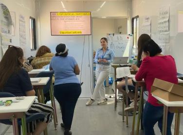
Future Stars mission is to provide opportunity for youth to achieve their goals in higher education through technology and sports. We provide them the opportunity through our multiple programs. Our programs are Hands On STEM Program, Hands On STEM Fair, Coding Stars, Career and College Readiness and Title 1 Tech. We have partnered with other organizations to provide STEM workshops to their communities.
Since 1912, YWCA Metropolitan Phoenix has been on a mission to eliminate racism, empower women, and promote peace, justice, freedom, and dignity for all. YWCA’s mission lives in the heart of employees, volunteers and partners and demands a world of equity and human decency.
The Navajo Tribal Utility Authority (NTUA) was established on January 22, 1959, to address the absence of utilities on the 27,000 square-mile Navajo Nation. Since then, NTUA has grown into a self-sustaining, not-for-profit, successful tribally-owned enterprise.

The Quilt is the national coalition of non-profit U.S. regional research and education networks representing 43 networks across the country. A collaboration of U.S. research and education networks committed to innovation and advancement of these purpose-built networks that empower our public service missions.
Sahuarita Food Bank & Community Resource Center is coordinating a broad range of services and resources for rural Arizona and underserved Pima County.

Dec 10, 2024
The promise of faster, more reliable internet for Apache County took a step forward on Nov. 26 with a ceremonial groundbreaking in St. Johns outside the Apache County Annex Building. The milestone marks the county’s broadband expansion project, which aims to connect nearly 3,200 homes and businesses in the area.
December 9, 2024
Roughly 175,000 Arizona homes still lack access to broadband internet, and many of them are in tribal and rural communities; the state Commerce Authority says it’s looking to change that.

Monday, November 25, 2024
Arizona's goal is to provide dependable and affordable high-speed internet services to every community and access to the necessary digital skills, so every resident can fully participate in a digital world. This is look at the team of elected officials who will be Arizona’s voice in Washington.
The N50 Project accelerates digital adoption and community enrichment through innovative applications, network design, and business models to enable the next 3 billion people to participate in the digital world.

Nov 14, 2024 - This memo proposes the modernization of the Enhancing Education Through Technology (E2T2) Program as part of the overdue Elementary and Secondary Education Act’s (ESEA) reauthorization.

Oct 11, 2024 - From 5G connections, to Roblox game design, and even finding new ways to transcribe the physical world using technology, read about how ASU is helping transform the digital landscape.
Oct 2, 2024 - Baltu Technologies and Downtown Mesa Library are using VR and AR to prepare for an infrastructural evolution
Digital Connect® is an initiative of Gila River Telecommunications, Inc. Our goal is to bridge the digital divide in the Gila River Indian Community and Indigenous communities everywhere through digital skills trainings, support services, and learning resources that are easy to understand and readily accessible, and to develop future generations of Indigenous people as leaders in technology. The GRTI board of directors created DCI in recognition of the need to promote digital inclusion, leverage broadband connectivity for community and economic advancement, and embrace modern technology as a resource for heritage preservation in the digital age. As a technology leader, Gila River Telecommunications, Inc. is the ideal host for the Digital Connect Initiative.

September 19, 2024
The City of Flagstaff is partnering with Arizona-based internet service provider Wecom Fiber to deliver high-speed, broadband internet to homes and businesses across the city.
NTIA and the U.S. Census Bureau have embarked on an experimental project to produce single-year estimates of Internet adoption for small areas, addressing a key gap in available data to better serve the policymaking process.
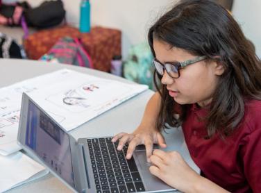
Sep 13, 2024 - ASU Preparatory Academy and Girls Who Code have teamed up to prepare future leaders of STEM with valuable tools
We Care Tucson provides individuals with access to information technology, medical equipment, and supplies. Through the restoration of donated computers and reusable medical devices, including the responsible recycling of non-functional components, we strive to cultivate an equitable and sustainable community in Southern Arizona.
EveryoneOn Arizona is a statewide organization that supports the sign-up process for the Affordable Connectivity Program. They assist individuals and families in applying for affordable internet plans, ensuring that everyone has access to essential online resources and opportunities.
Arizona Western College has initiatives in place to promote digital equity and workforce training. They offer computer access to students and provide resources for digital skill development. Additionally, the college collaborates with local businesses and organizations to create workforce training programs aligned with industry needs.
The Arizona Telemedicine Program promotes telehealth services by facilitating access to healthcare providers, telemedicine networks, and training programs. They play a crucial role in advancing healthcare delivery through the use of technology and remote healthcare services.
The Arizona Technology Council focuses on promoting technology innovation and workforce development, supporting businesses and startups in the technology sector. ATC provides resources, networking opportunities, and advocacy for technology-related initiatives.
GetSetUp is a virtual older adult learning platform that first focuses on the digital equity/inclusion, then after users understand their device we offer classes in physical health, mental health, workforce development as well as cybersecurity.
ADIN is a growing coalition of organizations and individuals from across Arizona working to advance affordable household and free public internet access, device ownership, digital skills training, online safety and technology support.
Mil Geospatial LLC, is a Geographic Information Systems (GIS) consulting firm, recognized as a small business and a minority owned enterprise located in Phoenix metro area.