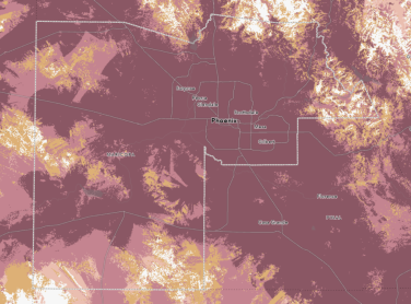
What FCC Data Reveals About Arizona Connectivity
March 31, 2026 - Mapping momentum of FCC Broadband Data | December 2024 - June 2025
March 31, 2026 - Mapping momentum of FCC Broadband Data | December 2024 - June 2025
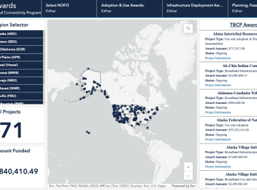
The Tribal Broadband Connectivity Program is a $3 billion program available to Tribal Governments, Tribal Colleges and Universities (TCUs), the Department of Hawaiian Home Lands (DHHL), Tribal organizations, and Alaska Native Corporations (ANCs).
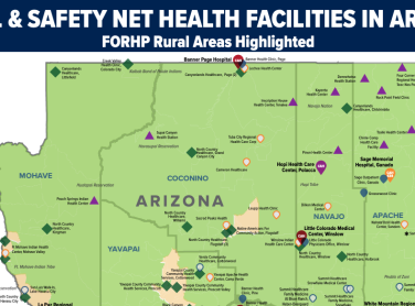
Explore maps from the University of Arizona related to Rural Health Safety Nets and Tribal Health Facilities,

December 17, 2025 - Inside SCN’s fiber strategy for sustainable middle mile infrastructure
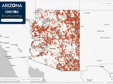
This map is designed to identify unserved and underserved areas, providing a clear view of broadband infrastructure needs across Arizona. This map supports state, local, and federal initiatives by visually representing connectivity gaps and progress.
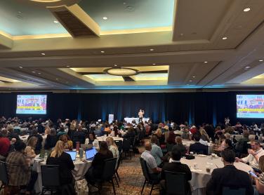
September 12, 2025 - What we learned at the 2025 Arizona Geographic Information Council (AGIC) Education and Training Symposium

July 14, 2025, - FCC data updates from June 2024 to December 2024 show how data center development drives higher internet speeds.
June 11, 2025 - Sharing digital equity insights to ignite change and amplify our impact in the digital inclusion movement

Feb 18, 2025, - FCC data updates from December 2023 to June 2024 show where internet speeds are rising...and where they are falling.

Feb 18, 2025 - How Sun Corridor Network Facilitates Sharing Knowledge Across Arizona

The Arizona Broadband Map was created in partnership with Maricopa County, and made possible by ARPA funding, to provide insights into the current state of internet access and relevant socioeconomic factors and aid in identifying areas that could benefit from digital equity efforts.
January 3, 2025
Residents of unincorporated Yavapai County will soon be able to have high-speed internet in homes and businesses. Back on December 21st, Yavapai County officials and dignitaries, along with representatives with Wecom Fiber, broke ground to commemorate work beginning to install broadband services to Cordes Lakes, Spring Valley, White Horse Ranch, Paulden, Rimrock and Beaver Creek.
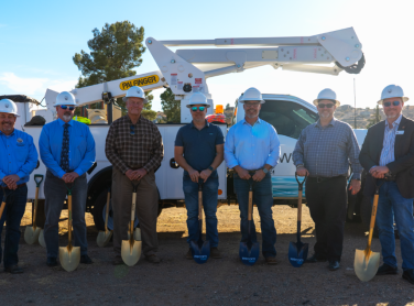
January 2, 2025
The long-awaited news that the Graham County Regional Fiber Project will be funded came from the Arizona Commerce Authority’s -Broadband Office.

The Quilt is the national coalition of non-profit U.S. regional research and education networks representing 43 networks across the country. A collaboration of U.S. research and education networks committed to innovation and advancement of these purpose-built networks that empower our public service missions.

Oct 11, 2024 - From 5G connections, to Roblox game design, and even finding new ways to transcribe the physical world using technology, read about how ASU is helping transform the digital landscape.
Oct 2, 2024 - Baltu Technologies and Downtown Mesa Library are using VR and AR to prepare for an infrastructural evolution
NTIA and the U.S. Census Bureau have embarked on an experimental project to produce single-year estimates of Internet adoption for small areas, addressing a key gap in available data to better serve the policymaking process.

Sep 13, 2024 - ASU Preparatory Academy and Girls Who Code have teamed up to prepare future leaders of STEM with valuable tools
GetSetUp is a virtual older adult learning platform that first focuses on the digital equity/inclusion, then after users understand their device we offer classes in physical health, mental health, workforce development as well as cybersecurity.
Mil Geospatial LLC, is a Geographic Information Systems (GIS) consulting firm, recognized as a small business and a minority owned enterprise located in Phoenix metro area.

Connected Journeys: Stories of Broadband and Digital Equity
This page contains a StoryMap with analysis of changes from June 2023 dataset to December 2023 dataset.

Mapping Broadband Health in America is a novel, interactive mapping platform created by the Connect2HealthFCC Task Force.
The Connect2HealthFCC Task Force’s (C2H Task Force) Advancing Broadband Connectivity as a Social Determinant of Health Initiative is based, in part, on the Task Force’s prior and ongoing research and analytics showing a significant correlation between increasing broadband access and improved health outcomes.
The American Indian Policy Institute is home to the newly formed Center for Tribal Digital Sovereignty, formed in partnership with the National Congress of American Indians. This Center is the first and only one in the nation dedicated to helping tribal governments, leadership, and communities understand the complexities of digital sovereignty. It provides access to resources and serves as a clearinghouse for tribal digital sovereignty. The center works towards the following goals and concepts: scholarship, capacity building, policy research and advocacy, and forming a coalition of organizations that work together to support tribes.